

The Challenge
People who live, work, and attend school near heavily traveled roadways can experience higher exposure to traffic-related air pollution. Understanding the relationship between roadway proximity, pollutant exposure, and human health requires researchers to accurately characterize localized air quality conditions and evaluate how those conditions affect different populations over time.
University and government researchers needed specialized air quality and exposure expertise to investigate these relationships and better understand the potential health effects associated with living near major roadways and other significant sources of vehicle emissions.
Our Solution
For more than 20 years, Spheros Environmental has worked with university and government researchers to evaluate the relationship between traffic-related air pollution, exposure, and human health.
The team has applied a range of methods to characterize near-road pollution, including GIS-derived traffic density metrics, near-road air quality measurements, exposure assessments, and CALINE4 dispersion modeling. These approaches have supported research examining lung function and development, asthma and other respiratory diseases, cardiovascular disease, birth outcomes, and other health effects in children and adults.
Spheros’ work has also evaluated air quality impacts associated with port-related vehicle traffic and explored strategies for reducing exposure in communities near major roadways, including research into the effectiveness of HVAC filtration systems at near-roadway schools.
Air Quality and Exposure Research Consultant
Results +What makes this unique
This long-term body of research has helped demonstrate important relationships between traffic, roadway proximity, air pollution exposure, and human health. Studies conducted by Spheros scientists and their collaborators have found measurable differences in pollution exposure and health outcomes among populations living near major roadways.
The work brings together air quality science, exposure assessment, traffic analysis, GIS, monitoring, dispersion modeling, and health research to examine complex near-road pollution challenges from multiple perspectives. More than two decades of collaboration with university and government researchers have contributed to the scientific understanding of traffic-related air pollution and provided evidence that can inform future air quality, transportation, public health, and exposure-reduction strategies.
Illustrations of near-road and traffic-related health and air quality impacts:
- Residential Proximity to Freeways and Autism in the CHARGE Study
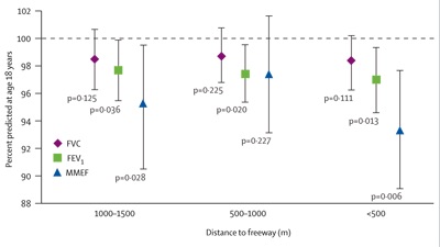
- Effect of Exposure to Traffic on Lung Development from 10 to 18 Years of Age: A Cohort Study
- Traffic, Susceptibility, and Childhood Asthma
- Predictors of Intra-Community Variation in Air Quality
Illustrations of GIS-derived traffic density metrics and associated health effects:
- Prospective Analysis of Traffic Exposure as a Risk Factor for Incident Coronary Heart Disease: The Atherosclerosis Risk in Communities (ARIC) Study
- Exposure to Traffic: Lung Function and Health Status in Adults with Asthma
Illustration of near-road NO2 measurements and explanatory factors:
Illustrations of port-related traffic and air quality impacts:
- Exposure of PM2.5 and EC from Diesel and Gasoline Vehicles in Communities Near the Ports of Los Angeles and Long Beach, California
- Mitigating Diesel Truck Impacts in Environmental Justice Communities: Transportation Planning and Air Quality in Barrio Logan, San Diego, California
Illustration of near-road CALINE4 dispersion modeling analysis:
Illustration of near-road air pollution mitigation: